|
From the Essential to the Bizarre...
Use our currency converter to find out the current exchange rates! The Indian Flag
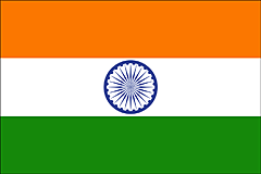
Indian flag courtesy of 4 International Flags LocationIndia is located in the northern hemisphere in the continent of Asia (south). India shares its borders with Nepal and China to the north, Bhutan in the north-east, Myanmer and Bangladesh to the east and Pakistan to the west. Off is south-eastern coast lies Sri Lanka and the Maldives. The Bay of Bengal are the waters of India's eastern coast, the Indian Ocean to the south and the Arabian Sea to the west. Within these waters are India's islands, the Andoman and Nicobar Islands to the east and the Lakshadweep Islands in the west. Click here for a map of India! Capital CityIndia's capital is New Delhi. It has a population of about 12.5 million people and an area of 1,483 sq km. For a map of Delhi, click here!
AreaIndia's total area is 3,287,240 km2 or 1,269,210 square miles. This makes India the 7th largest country in the world, and the second largest in Asia. India extends 3,214 km or 1,997 miles north to south, and 2,933 km or 1,822 miles east to west. It is slightly more than one third the size of the United States, and about 20 times larger than the UK.
TimeIndian Standard Time (IST) is GMT + 5.5hours. India does not observe Daylight Saving. Indian Standard Time is calculated on the basis of 82.5° E longitude - near Allahabad in Uttar Pradesh state.
Indian PoliticsIndia is the largest democracy in the world and follows a parliamentary system of government known as the Westminster System after that of the U.K. The President of India is Pratibha Devisingh Patil, the first woman to have assumed the role. The role of President dates back to January 26th, 1950 when the first president (Rajendra Prasad) was elected after independence in 1947. The President's position as head of state can be loosely compared to the role of the monarch in the United Kingdom, with substantial reserve powers, but no real executive power. The current Prime Minister of India is Manmohan Singh. The Prime Minister of India is the head of government in India, and head of the Council of Ministers. He/She is appointed by the President, and recognized as the head of the majority party. National political parties in India include the INC (currently the leading party in a coalition known as UPA), the NCP, the CPI and the BJP. As well as these, there are more than 35 recognised state parties.
LanguageThe official language of the Republic of India and most widely spoken language is Hindi. English is used extensively in business, administration and education. There is no recognised 'national language' defined in India. There are 22 official languages in India, with many states adopting native languages as their official tongue. Significant official languages spoken in India other than Hindi and English include Urdu, Punjabi, Tamil, Malayalam, Konkani, Telugu, Marathi, Kannada and Bengali.
Indian Religion
States of IndiaThe 28 states of India are Andhra Pradesh, Arunachal Pradesh, Assam, Bihar, Chhattisgarh, Goa, Gujarat, Haryana, Himachal Pradesh, Jammu and Kashmir, Jharkhand, Karnataka, Kerala, Madhya Pradesh, Maharashtra, Manipur, Meghalaya, Mizoram, Nagaland, Orissa, Punjab, Rajasthan, Sikkim, Tamil Nadu, Tripura, Uttar Pradesh, Uttarakhand and West Bengal. India's 7 Union Territories are Andaman and Nicobar Islands, Chandigarh, Dadra and Nagar Haveli, Daman and Diu, Lakshadweep, National Capital Territory of Delhi and Puducherry. Economic Facts About IndiaIndia is a rapidly growing economy. Currently its GDP is the 12th largest in the world - it is predicted that by 2020, India will be among the leading economies of the world. The service industry accounts for 54% of India's GDP, with 29% representing industrial, and 17% agricultural sectors. The work force in India is over half a billion with 60% of these employed in the agricultural sector. Agricultural products include rice, wheat, tea, sugarcane, cotton, potatoes, fish, poultry and water buffalo. Main industries include textiles, chemicals, petroleum, mining and software. India's main exports are petroleum and related products, textiles, jewellery and gemstones, chemicals, leather goods and engineering goods. India's main trading partners are China and the US. Despite rapid growth, around 80% of India's population live on $2 or less a day, and the economic divide broadens. Sadly, 22% of the population still live below the poverty line, with many struggling on little more. Educational Facts About IndiaEducation among the young in India is improving, with free education provided up until the age of 14. Numbers in secondary education, however, remain low and India has the largest illiterate population of any country in the world. Efforts are being made to improve literacy, especially among women where the rate is lowest at 54.5%. Overall, around 66% of India's population are literate, though a steady growth is occuring. At a tertiary level, the emphasis is on science and technology, with popular choices also covering business management and IT. India has 13 universities which provide both an exceptional level of education and are deemed as having national importance. There are many more providing excellent levels of higher education, but also a large number of questionable quality.
SportOne of the less known facts about India is that field hockey is India's national sport. It is cricket, however, that wins the heart of the nation, being by far the most popular sport. Other popular sports in India include football, badminton, volleyball, kabaddi, golf, basketball and kite flying. Sports / activities popular with tourists and growing numbers of Indian enthusiasts alike include scuba diving, sea kayaking, paragliding, white-water rafting, snow sports, mountain biking and trekking. Fun Facts About India
Want to know more facts about India? Try our pages on Indian religion and Indian festivals. Click here to leave Facts About India and return toTravel India Goa Guide Home
Currency Converter -
India Tourist Informatiom -
Pictures Of India -
India Map -
India City Maps
|
|
Picture galleries on this siteSome of our favourite travel pictures of Goa. Find many more Goa pictures in our Goa guide. The stunning landscapes of Kerala. Find many more Kerala pictures on our travel to Kerala guide. Some pictures of India to inspire adventurous travellers... |


